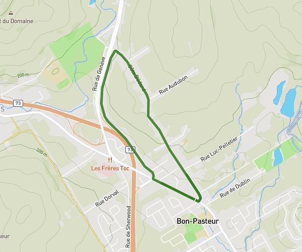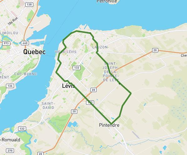
Esta ruta de senderismo cubre 12.634mi desde Château-Richer, Quebec. La caminata no regresa al punto de partida y termina cerca de Côte De La Fabrique, G1R 3V6 Québec. Esta ruta está clasificada como fácil, estima 12m para completarla. El recorrido tiene un desnivel positivo de 581ft y negativo de 446ft.
Descripción del curso por el Creador
Para más información sobre la ruta de Notre-Dame de Québec, consulte: <a rel="noopener noreferrer" target="_blank" href="https://www.kapoah.com">https://www.kapoah.com</a>. Día 1: <a rel="noopener noreferrer" target="_blank" href="https://www.map-planner.fr/utilisateurs/kapoah/parcours/kapoah-1-10-la-malbaie-quebec-jour-1">https://www.map-planner.fr/utilisateurs/kapoah/parcours/kapoah-1-10-la-malbaie-quebec-jour-1</a> Día 2: <a rel="noopener noreferrer" target="_blank" href="https://www.map-planner.fr/utilisateurs/kapoah/parcours/kapoah-2-10-la-malbaie-quebec-jour-2">https://www.map-planner.fr/utilisateurs/kapoah/parcours/kapoah-2-10-la-malbaie-quebec-jour-2</a> Día 3: <a rel="noopener noreferrer" target="_blank" href="https://www.map-planner.fr/utilisateurs/kapoah/parcours/kapoah-3-10-la-malbaie-quebec-jour-3">https://www.map-planner.fr/utilisateurs/kapoah/parcours/kapoah-3-10-la-malbaie-quebec-jour-3</a> Día 4: <a rel="noopener noreferrer" target="_blank" href="https://www.map-planner.fr/utilisateurs/kapoah/parcours/kapoah-4-10-la-malbaie-quebec-jour-4">https://www.map-planner.fr/utilisateurs/kapoah/parcours/kapoah-4-10-la-malbaie-quebec-jour-4</a> Día 5: <a rel="noopener noreferrer" target="_blank" href="https://www.map-planner.fr/utilisateurs/kapoah/parcours/kapoah-5-10-la-malbaie-quebec-jour-5">https://www.map-planner.fr/utilisateurs/kapoah/parcours/kapoah-5-10-la-malbaie-quebec-jour-5</a> Día 6: <a rel="noopener noreferrer" target="_blank" href="https://www.map-planner.fr/utilisateurs/kapoah/parcours/kapoah-6-10-la-malbaie-quebec-jour-6">https://www.map-planner.fr/utilisateurs/kapoah/parcours/kapoah-6-10-la-malbaie-quebec-jour-6</a> Día 7: <a rel="noopener noreferrer" target="_blank" href="https://www.map-planner.fr/utilisateurs/kapoah/parcours/kapoah-7-10-la-malbaie-quebec-jour-7">https://www.map-planner.fr/utilisateurs/kapoah/parcours/kapoah-7-10-la-malbaie-quebec-jour-7</a> Día 8: <a rel="noopener noreferrer" target="_blank" href="https://www.map-planner.fr/utilisateurs/kapoah/parcours/kapoah-8-10-la-malbaie-quebec-jour-8">https://www.map-planner.fr/utilisateurs/kapoah/parcours/kapoah-8-10-la-malbaie-quebec-jour-8</a> Día 9: <a rel="noopener noreferrer" target="_blank" href="https://www.map-planner.fr/utilisateurs/kapoah/parcours/kapoah-9-10-la-malbaie-quebec-jour-9">https://www.map-planner.fr/utilisateurs/kapoah/parcours/kapoah-9-10-la-malbaie-quebec-jour-9</a> Día 10: <a rel="noopener noreferrer" target="_blank" href="https://www.map-planner.fr/utilisateurs/kapoah/parcours/kapoah-10-10-la-malbaie-quebec-jour-10">https://www.map-planner.fr/utilisateurs/kapoah/parcours/kapoah-10-10-la-malbaie-quebec-jour-10</a>